Instead of extending the current design-for-the-car into the future, we could shift the key variables of the current system and design a future that empowers environment and citizen mobility.
In early 2017, we became homeowners and moved to our new home right after my retirement from service in the U.S. military. Our new home was located in a new community surrounded by the green Texan forest and a landscape painted by small hills—just beautiful! I remember our daily walk outdoors, especially in the afternoons, watching the sunsets were majestic events. Late in the evenings, we could hear the coyotes calling, and in the mornings, the sounds of nature would welcome us to a bright and shiny day. Seemed like humans and nature could cohabitate.
A little over half a year passed, and we came back from a vacation to find hundreds of square miles of forest gone. We looked in shock at the bare hills. How could this happen? Is somebody watching this? I reasoned as I looked at the hills that continued to be deforested to make more place for housing developments. Traffic in the area also changed: congestion is everywhere, as heavy machinery deforests more land to widen and add lanes to the old country roads. The forecast is that we will have increased traffic, and it needs to be accommodated. All of that change in less than two years. What will the future hold?
Growing Trend with Serious Consequences.
The situation I just described is the result of a phenomenon happening all around the world, not just in my city. This is the phenomenon of Urban Sprawl, where population densities grow faster outside the core urban areas of the city, taking various spatial forms and a greater proportion of available land area. One could explain the reasons through what the international community sees as trends in population migrations. For example, the United Nations reported in its 2018 Revision of the World Urbanization Prospects that urban residents makeup 55 percent of the world’s population and will reach 68 percent by 2050. By the UN estimates, North America already counts as one of the most urbanized regions in the world. The growth is not expected to stop, and we all see it regardless of the continent we choose to live in.
What leaders across the world are concerned (as we all should) is the effects of this growth on a multitude of levels. Chief among these concerns is how we manage the environmental quality of large cities. In China, for example, the rapid urbanization has led to problems of air and water quality, plus another major issue: inadequate water supplies. Overall, the Organization for Economic Co-operation and Development (the 34-member country organization known as OECD) concluded that urban sprawl around the world has led to higher transport emissions, the loss of open space and environmental amenities, as well as the increase in the cost of public services and the reductions of affordable housing. All are effects anyone who has lived in major cities have surely felt.
Thinking Differently.
Can we solve this problem? Prescribing an antidote to such a complex problem cannot be done through traditional problem-solving methods that emphasize linear thinking. City sprawl is the result of processes, causes, and effects that are interrelated and interdependent—it’s a system of systems. Consequently, linear thinking will not help us understand the complexities of a system’s world. We need to employ system’s thinking. If we can analyze the problem from a system’s perspective, we will have a better chance of affecting it, thereby making meaningful impacts with reduced unintended consequences. In effect, we could create a better future.
One way to analyze the system is through system dynamics’ use of Causal Loop Diagrams. Below, I use Causal Loop Diagrams (CLDs) to paint the key variables of the city sprawl situation, to see how these variables are interconnected, and see how these interconnections result in a system and its behavior. CLDs help us uncover systems and their structures, which we cannot uncover with simple linear thinking. System structures are at the core—they generate the patterns of behavior that are the root cause of the problems we see in the world. From this view, we can then hypothesize about the problem and its solutions.
Current State.
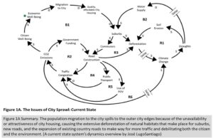
Based on what we have discussed, let me depict briefly the city sprawl situation as a system with its key variables, reinforcing, and balancing loops. Figure 1A depicts that state.

Figure 1A is the current state. (See also note 5 below for a short explanation on the symbols.) We enter the CLD in loop B1 at the green point: Economic well-being. Economic well-being drives migration to the cities, where people seek the promise of better jobs. The increased migration to the city creates a shortage of affordable, quality housing, which drives people to seek housing in the suburbs. The larger the demand for suburbs, the greater is the increase in deforestation efforts to make space for new homes (entering loops R1 and B1). The deforestation leads to other effects that may not be felt immediately, but when left unattended, these effects can become irreversible (R1). The effects of R1 affects the condition of the water supply, which in turn will lead to the decision of whether to pursue more suburb development or not due to the condition of water capacity.
Continuing in loop B1, with the increased in suburbs, comes an increase in commuting. People add miles over miles to get to work and back home. Government funding is spent on roads to alleviate this problem, which affects the behavior of commuters. For example, the more the government spend on roads, less is done to build public transportation systems (R4) and more is done to reward commuters who will turn to increased use of privately owned vehicles (POV), affecting traffic congestion, worsening the CO2 situation and further deteriorating the environment, and the citizen’s wellbeing. In the end, nature and citizen pay the most. The effects are the nearly irreversible declines in the health of both the environment and the citizen.
What could the problem be?
Can we stop city sprawl? Perhaps not. People will continue to move based on many factors (and key drivers as we just discussed). One thing we could do is shift the structure of the system to help us manage the negative effects of city sprawl. We can do better at improving the wellbeing of both the citizen and the environment. Both environment and citizen can co-exist.
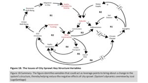
What if we could identify key variables in the system to help us make a shift? We could state a simple hypothesis of the problem, given the system depicted in Figure 1A, in the following manner:
Hypothesis: A system structure that focuses on the human being (rather than building for the car) will benefit both the citizen and the environment.
Figure 1B identifies (in red) the variables that could act as leverage points to bring about a change in the system’s structure, thereby helping reduce the negative effects of city sprawl and improve the chances of well-being for both the environment and the citizen.

Instead of extending the current design-for-the-car into the future, we shift variables of the current system (those in red, in Figure 1B) and design a future that empowers citizen mobility (car independence).
Future State.
What if we could take the variables identified in Figure 1A and eliminate or change them? This means shifting the government’s mindset from one that invests in car mobility to one that invests on citizen mobility (physical and technological mobility). Having the citizen in mind, the city is designed as an all-inclusive community with accessibility everywhere. Suburb’s existence is carefully linked to the city with green forms of transportation. Neighborhoods improve citizen mobility through better integration of commercial and public services; accessibility by walking and use of bicycles is everywhere.
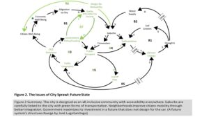
Government funding and policy maximizes its investment in a future that does not design for the car, benefitting both citizen and environment. This future is seen in Figure 2.

The future state in Figure 2 shifted government policy and funding to provide the cities with the needed help to build all-inclusive communities with quality, affordable housing (B7). Therefore, the more affordable, all-inclusive the community is in the city, the less sprawl occurs, controlling the excessive build-up of suburbs, and consequently, controlling the amount of deforestation that happens all around the city. Government funding and policy focus shifted to one devoted to public transport (B5), minimizing the amount of pollution and destruction that occurs through the widening and design of more roads. This shift provides an incentive for citizens to become less dependent on POVs, minimizing traffic congestion, CO2 emissions, and improving the health of the citizen through walkability.
Additionally, efforts were also shifted into developing suburbs as communities where citizens could access everything they needed by walking, bicycling, or by using public transportation and technology. This shift, changed the dynamics of the system, for example, reinforcing loops emerged as balancing loops (B3, B4, and B5). This shift, as depicted in Figure 2, positively reduced traffic congestion, CO2 emissions, climate change, deforestation, and therefore had positive effects on the citizen’s and the environment’s wellbeing.
Where do we go from here?
Capturing all of the variables in this high-level diagram is nearly impossible. But we can see some misfits in the current situation. A principal in the current state is the way we think and design for communities and mobility, thinking of the car as the default mobility instrument. This thinking debilitates all other alternatives and future investments in public transportation, technology mobility, environmental sustainability, and citizen’s health. In short, this thinking denies us a better future where both the environment and the wellbeing of citizens can win.
In regards to the future state, misfits rise from unintended consequences. For example, one of them is the creation of policy and laws that could produce more sprawling. In this sense, policy and laws need to be analyzed through the system dynamics’ lens and tested during simulations to see the directional effects that policy and laws have in the system. Additionally, is worth remembering that every city has unique systems that may interact differently with other systems creating dynamics shifts.
The important thing to realize is that city sprawl is a real problem that will have irreversible critical effects if we don’t act now. Attempts to resolve this problem (or others in complex systems) can no longer be done through thinking that emphasizes linearity. We need a new kind of thinking (systems thinking) to help us understand how a set of variables affect others, see the system in as much of a big picture as we can have, hypothesize solutions, and implement structural changes now to have a new future.
We need a new future, a future where humans and nature can co-exist. We are connected, and therefore, what we do to one, we do to the other.
Special Thanks: This article was first published by LS|EG in November 28, 2019. It is published here, at the Journal of Leadership & Strategic Foresight with LS|EG’s permission.
References and Notes:
[1] Morçöl, G. (2012). Urban sprawl and public policy: A complexity theory perspective. Emergence : Complexity and Organization, 14(4), 1-16; Oueslati, W., Seraphim, A., & Garrod, G. (2015). Determinants of urban sprawl in European cities. Urban Studies (Edinburgh, Scotland), 52(9), 1594-1614.
[2] United Nations. (2018). World Urbanized Prospects 2018: Key Facts. United Nations DESA Population Division. Retrieved from https://population.un.org/wup/Publications/Files/WUP2018-KeyFacts.pdf.
[3] Daniels, T. (2008). Works on green cities: Form potential to imperative. Journal of the American Planning Association, 74(4), 521.
[4] Organization for Economic Co-operation and Development. (2018). Rethinking Urban Sprawl: Moving Towards Sustainable Cities. 6. Retrieved from https://www.oecd.org/environment/tools-evaluation/Policy-Highlights-Rethinking-Urban-Sprawl.pdf.
[5] In the CLDs, the arrows point to the direction of flow. The “S” and “O” explained the effects of one variable onto another. For example, on the variable “Migration to City,” the migration produces the opposite (“O”) effect on the next variable. The more migration to the city, the less quality and affordable housing is available (the less migration to the city, the more quality and affordable housing will be available). The “S” is for the same effect. For example, the more “Suburbs” that exist, the more “Commuters” will also exist (the less “Suburbs” that exist, the less “Commuters” will also exist). The “R” are for reinforcing loops—those that seek to compound change on one direction. The “B” stands for balancing loops—those seeking to stabilize or correct a gap in state behavior.

